Unfolded Studio

Unfolded Studio

Explore a world of data with advanced geospatial analytics

4 followers

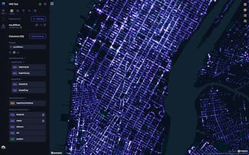
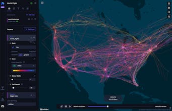
🌍 Unfolded Studio is a geospatial analytics platform that makes it easy to drag and drop LARGE datasets to create powerful visualizations from your browser and share with the team!
Unfolded Studio gallery image
Launch tags:Analyticsβ€’SaaSβ€’Developer Tools
Launch Team
Anima Playground
AI with an Eye for Design
Promoted

What do you think? …

Chun Jiang
🌍 Hello everyone! πŸ™‹ I’m Chun, Head of Product of Unfolded.ai, a geospatial analytics startup coming out of Uber. We are so excited to show you Unfolded Studio, designed for broad industry use cases and challenges like handling big data, geospatial unification and temporal analytics. Geospatial data is critical for answering tough questions, from preventing the spread of crop disease to optimizing delivery routes. Our founders have been developing advanced geospatial technologies like kepler.gl, deck.gl and H3 for over half a decade and have now joined forces to reinvent geospatial analytics. πŸ›Έ Unfolded Studio makes it easy to.... - Display million-row tables in the browser - Join datasets with unified format - Perform advanced temporal analytics - Publish and share your map in one click - Build custom applications ❀️ But we are more than just a platform. We are a community! With over 1200 users already on board, we’re getting great feedback and seeing amazing maps being generated. We’d love to welcome you into the fold (pun intended)! πŸƒβ€β™€οΈ Sign up for your free account at https://www.unfolded.ai/studio and join our community Slack http://bit.ly/3qRZBB7. πŸ‘€ We are so excited to hear everyone’s thoughts! Leave us a comment, or email us at info@unfolded.ai with any feedback! Thank you!
Jake Goldstein
Are you guys going to offer existing data sets? For example, the US Census Bureau ACS 5 year survey.
Miriam Young
@jake_goldstein great question - we do indeed have an ever-growing data catalog including some census data! Suggestions like this are great though as we figure out future updates. Will pass the feedback along!
Jake Goldstein
@miriam_young Awesome, I ask bc aggregating it is a pain and would save tons of time. I would pay for it.
Chun Jiang
@jake_goldstein Hi Jack! Yes we can help you find the right data and unify and aggregate it easily. Let's chat! https://calendly.com/chunonline/...
Jake Goldstein
@cj326my Sounds good!
Chris Messina
Wow, look out Mapbox β€” this looks gorgeous!
Miriam Young
@chrismessina thanks so much for your support!
Ben Kramer
Globes are so hot right now... *and* the globe is so hot right now. Looking forward to seeing how this is used in the climate tech space! πŸ˜…
Miriam Young
@benkramer YES very true on both fronts. Such an urgent issue and geospatial data has so much potential to help inform our response to the climate crisis. Thanks for your support!
Chun Jiang
@benkramer danke ❀️
Shane Ham
I've been following Kepler.gl for almost two years now, and am incredibly pumped for Unfolded Studio + team! Geospatial intelligence is the future, especially in logistics + supply chain!
Miriam Young
@shane_ham Thank you so much! We're super excited to craft the future of geospatial intelligence with our growing community!
Hany Elfouly
What an amazing tool, I've been following the team and unfold since kepler.gl release and before the unfold website was fully functional and they decided to start this project and can't what to see how much will come out of this brilliant team and their product. Glad to be one of the early adopters
Miriam Young
@hanyelfouly we are SO glad to have you in the community and look forward to pushing the envelope on what great geospatial tooling can look like!
Ryan Cunningham
While at Uber, I was a power user for our internal predecessor to this tool (Voyager, built on kepler.gl). It is hands-down the BEST geospatial analytics tool out there, and is perfect for presentations and animations. We used it internally and in public events like the Uber Elevate summit. It can do it all – LiDAR files, shapefiles, simulation outputs, anything you can throw at it. You'll blow your audiences away!
Miriam Young
@rydcunningham thank you!!
12
Next
Last