

Ultimaps — Color Coded Maps Reinvented
Create Beautiful and Interactive Map Charts in Seconds
16 followers
Create Beautiful and Interactive Map Charts in Seconds
16 followers
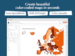
Create color-coded maps and charts from Excel files or AI prompts in seconds. No more complex interfaces - you bring data and we focus on its presentation.
Maps can be exported into a printable format or extended with interactive elements and shared via link or embedded onto a website.


Free Options
Launch Team / Built With


Wispr Flow: Dictation That Works Everywhere — Stop typing. Start speaking. 4x faster.
Stop typing. Start speaking. 4x faster.
Promoted

Maker
📌Report